| Main Categories |
| Audio & MP3 |
| Business & Finance |
| Games |
| Desktop Enhancements |
| Home & Education |
| Internet Tools |
| Multimedia & Design |
| Software Development |
| Utilities |
| Web Authoring |
| Mac Software |
Radar Screensaver 1.0
The Radar Screensaver is a modern and outstanding screensaver which is able to turn your video display into a screen of a fabulous radar watching the skies, seas, and near-Earth space.
If you have two or more monitors connected to your PC, you will be able to configure it to show same or different situations on different displays. This will turn your workplace into something like real airspace observation outpost.
| Download Details: |
| |
| Version: | 1.0 | |
| File Size: | 2.69 MB | |
| License: | Shareware | |
| Price: | US$ 19.50 | |
| Order: | Buy Now | |
| Download: | Download Now | |
| Download ID: | 12160015 | |
| Downloads | 1615 | |
| System: | Windows XP/2000/98 | |
| Update Date: | 09-23-2005 | |
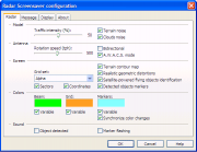
Features
- Bi-directional antenna
- Object markers
- Path tracking marks
- Main radar display
- Coordinate scale grids
- Variable colors
- Sector displays
- AWACS mode
- Detection log
- Satellite-powered object identification
- Terrain contour map
- Terrain/clouds noise
In this mode the radar antenna emits two radio beams instead of one.
These are animated overlaid rectangles with information about detected flying objects: azimuth, distance and speed.
Among with object markers you will find these broken lines which indicates previously determined positions of the flying objects.
It is at center of display and shows a situation around the radar site.
These are placed over the main and sector radar displays and might be used for precise flying objects coordinate determination.
You can choose the colors to paint all the elements of the animation.
These are the displays at screen corners.
In this mode, the radar antenna located aboard of the "Airborne Warning And Control System" aircraft.
There are two columns located at left and right display sides.
You will see an operation of identification system: it will take satellite photo of the object, recognize the type of object and will show its picture with name.
To simplify to the operator a task of determining where one or the other flying object flies at present time.
Copyright © 2003-2008 tomdownload.com - Shareware Downloads and Reviews Privacy | Terms of Use