| Main Categories |
| Audio & MP3 |
| Business & Finance |
| Games |
| Desktop Enhancements |
| Home & Education |
| Internet Tools |
| Multimedia & Design |
| Software Development |
| Utilities |
| Web Authoring |
| Mac Software |
TrekMapGPS 1.0
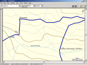
Annapurna Region GPS Map is the latest in an exciting new series of Garmin-compatible digital maps covering the major trekking and climbing regions of Nepal and the Himalaya.
TrekMapGPS products install on a PC for uploading to your GPS unit. The maps can be previewed in GarminˇŻs MapSource (not included) or other compatible software for route planning or reviewing.
| Download Details: |
| |
| Version: | 1.0 | |
| File Size: | 12.1 MB | |
| License: | Shareware | |
| Price: | US$ 33.00 | |
| Order: | Buy Now | |
| Download: | Download Now | |
| Download ID: | 14130012 | |
| Downloads | 1377 | |
| System: | Windows XP/2000/NT/98/Me | |
| Update Date: | 10-19-2006 | |
TrekMapGPS - Annapurna Region GPS Map Key Features:
* Over 1200 searchable Points of Interest (POIs), including:
* 716 towns and villages (ˇ°City? searchable)
* 384 elevation spots
* 12 passes
* 44 summits
* 91 glaciers and 41 lakes
* airports and other places of interest
* bridges and other man-made objects
* over 60 miscellaneous labelled locations
* 120+ accommodation areas and campsites
* Contours at 100m / 500m / 1000m intervals
* All major trekking routes, roads, tracks and paths
* Rivers and streams
* International and National Park borders
* Please note: the map is not routable
TrekMapGPS - Annapurna Region GPS Map Area Covered :
* E83ˇă 33.830' to E84ˇă 24.900'
* N28ˇă 08.995' to N28ˇă 51.035'
* extending beyond Beni in the west and Tal in the east;
* beyond Pokhara in the south and Kagbeni in the north .
Towns/villages including
* Pokhara, Jomsom, Chame, Besi Sahar, Kusma, Tatopani, Baglung, Beni.
Copyright © 2003-2008 tomdownload.com - Shareware Downloads and Reviews Privacy | Terms of Use